Memories of a mining state
Memories of a mining state
I hold in my hand 3 pieces of broken pottery. The fragments are a time machine that takes me back to the gold rush. Two pieces are plain and dusty brown, the size of my thumb. The third is smaller and bright, a tiny shard of white with a delicate blue pattern. All are tumbled and water-worn and almost certainly from the 1850s.
They are from Victoria’s central goldfields, country I have known for 30 years. I have loved this place since I arrived as a new migrant from Canada in 1989 and came to live in Ballarat. The cities and towns, forests, rivers, hills and back roads have become my second home, almost as familiar and almost as loved as the place I grew up. I am repeatedly drawn to the cultural life of this region with its history, art, events, food and wine, all grounded in an everyday economy of primary production on the land.
One of my favourite places is an informal picnic spot on the Loddon River near Newstead. I have visited it often with friends and our children. The river runs clear and brown over shallow gravel beds and has water holes perfect for paddling in. Mature eucalypts and shrubs line the banks and provide shade for us on a hot day and homes for the local birds. Grasses cover the higher sandbars where we have our lunch.
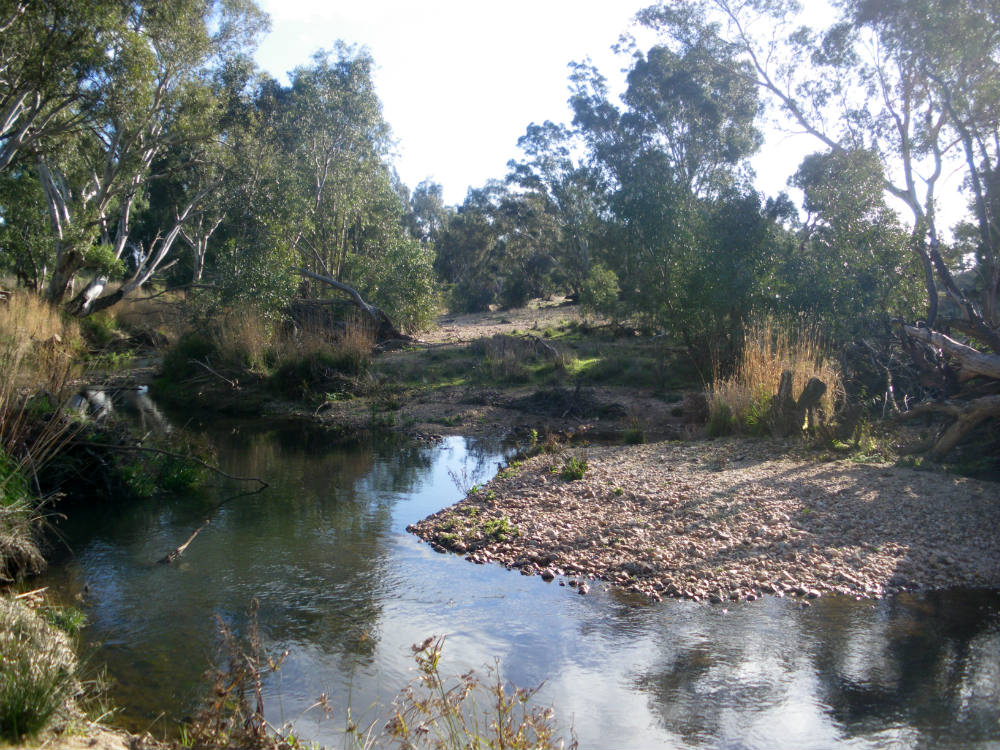
Photo: Susan Lawrence
Much as I love the beauty of this place I know that it does not look anything like the river that was here before white colonists arrived. Everything about my picnic spot was made by mining. Most of the mining was far away and a long time ago, upstream in the hills at Castlemaine, Guildford, Vaughn, Fryerstown, and Daylesford where the 1850s gold rush touched off 2 generations of mining. Some mining was much closer and more recent, on the flats at Strangways, where dredges worked in the 1930s and 1940s. Mining had a long reach that extended right down the Loddon and its tributaries all the way to Newstead.
The trees that give us shade are regrowth after the original forest was cut by miners. The waterholes are shallow because mining waste filled the deep holes that used to be here and that stored water over the dry summer months. The gravel in the river bed and the sands on the banks are mining waste too. They are ‘sand slugs’, mining debris eroded out of the dredge channel and carried downstream by floodwaters.
Even the shape of the river here is the result of mining. I can see the shape most clearly on old maps and GoogleEarth. The Loddon just upstream from where we sit is straight and narrow, entirely unlike natural meandering curves of a river that hasn’t been mined and unlike the river that is still there on the old maps. This river has changed a great deal over the last century and it will continue to change over the next century as the mining debris continues to wash down the Loddon. In a decade or so our picnic spot may be free of gravel, the sand bars carried downstream to someone else.
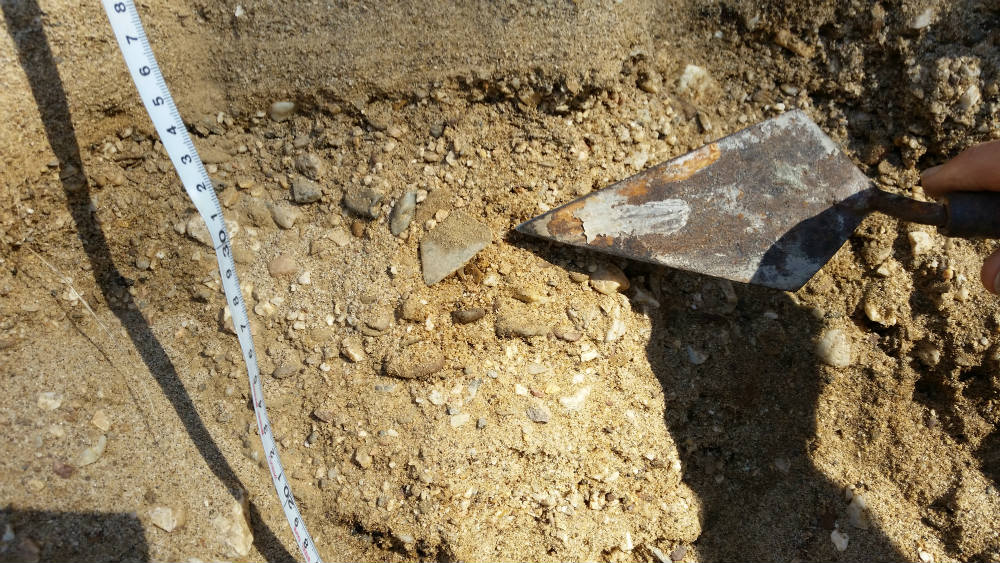
Photo: Susan Lawrence
The pottery I hold is from higher up on the riverbank and it tells the story of even greater changes to this river over the past 150 years. It was found by Harri, the son of a friend of mine, at a spot where the river bank is a cliff five metres tall. The layers of soil are now visible in the cliff and show how the river has changed. The lower section of the cliff is dark organic soil. Above it is a band of orange silt and gravel that is more than 2 metres thick. The pottery was about halfway up the bank in a layer of gravel just above where the dark soil ends. The dark soil is the original riverbank that the Dja Dja Wurrung people knew before the miners came. We can see from these layers that the floodplain on their river was at least two metres lower than the floodplain today. The old floodplain was buried by all the mining waste from upstream and the broad river flats filled with sludge. Later the river eroded down again to where it is now, much lower than the one the Dja Dja Wurrung old people knew.
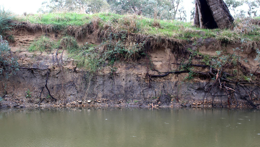
Photo: Susan Lawrence
How did the pottery come to be buried in the river bank? The fragments are rubbish, broken dishes thrown away by the miners. Coming to rest where they did on top of the old floodplain means that they must have been washed down with the gravels and silts. The pottery was at the bottom of the layers of mining waste so it was part of the first waves of sludge to come down the valley. The blue and white shard is a piece of teacup made in Staffordshire, England. It was marked on both sides with a pattern called ‘fibre’ popular in the 1850s and 1860s. Many people had dishes like that, not just the miners, and it could have come from anywhere before it ended up in the river.
The dull brown pottery tells a more detailed story. It comes from China where it was used to make containers for storing food. One of the pieces that Harri found could have been part of a jar to hold ginger or fish paste, rice or tofu. The other one might have been a bottle for rice wine, vinegar or soy sauce. This pottery came to Victoria holding food for the Chinese miners. It is unmistakably part of the gold rush. The nearest Chinese miners upstream from Newstead were up Jim Crow Creek towards Daylesford but the pottery probably came from the large Chinese village at Guildford. It travelled nearly 15 kilometres before it washed up with the sludge on the bank at Newstead.
These 3 pieces of pottery in the riverbank on the Loddon are some of the most exciting things I’ve ever found as an archaeologist. Everything about them combines to tell an astonishing story: their location at Newstead, their position in the layers of soil above the river, and the kinds of pottery they are. They tell us that this river, this place, has been profoundly different. Once it was a place of deep waterholes, reeds, and shady trees. The miners turned it into a sea of mud and rubbish. Then, over a very long time, the trees and grasses returned and the water ran clear. It is again a beautiful place in which to spend time. But it is not the same place, and it never will be.
Victoria has forgotten that it was once a mining state where huge holes were dug in farmland and industrial waste was pumped into the rivers without a thought for the consequences. The land remembers though. The land will remember in today’s mining states too long after the coal and the gas and the minerals are gone.
Susan Lawrence is an industrial archaeologist at La Trobe University, Melbourne.